Open Journal of Natural Science
Vol.
12
No.
01
(
2024
), Article ID:
79176
,
7
pages
10.12677/OJNS.2024.121013
乌鲁木齐机场2021年6月11日雷雨大风天气 特征分析
丁旭,杜安妮,李静轩,尹才虎
中国民用航空新疆空中交通管理局气象中心,新疆 乌鲁木齐
收稿日期:2023年12月6日;录用日期:2024年1月8日;发布日期:2024年1月15日

摘要
本文利用机场自动气象观测系统观测资料、乌鲁木齐机场航空器空中报告及ERA5再分析资料对2021年6月11日的雷雨大风天气进行诊断分析,了解雷雨大风天气形势特征及此类天气条件下风切变的变化特点及其对飞行的影响,以期提高此类对此类天气的预报预警能力。结果表明:(1) 此次雷雨大风天气为区域性强对流天气。500 hPa高空槽槽底不断分裂小股冷空气影响新疆地区,区域雷雨天气提供有利触发机制;700 hpa西南气流输送暖湿气流进入北疆区域,提供热力和水汽条件;850 hpa北疆沿天山一带受西北风带控制,明显的风向风速辐合配合天山北坡地形的强迫抬升作用,造成强上升运动,提供了动力条件。前期北疆大部区域地面气温高,冷空气东移造成冷暖空气交汇,造成此次强对流天气。(2) 雷雨天气初期冷空气进入本场,跑道两端风速骤增,风向变化大时易产生跑道两端水平风切变超标准,虽然风切变超标情况持续时间较短,但仍会造成航空器起降过程中难以保持飞行姿态,严重影响航空器飞行安全。(3) 跑道两端风速差及风向差较小时,不易产生风切变超标;跑道两端风速差大于6 m/s时,无论风向差值大小,均可能出现风切变超标。跑道两端风向差在30˚~90˚之间时,风速差异对风切变的影响权重逐步增大;两端风向差大于90˚时,不论风速差大小,均有可能出现风切变超标情况。
关键词
雷雨大风,动力条件,热力条件,水汽条件,水平风切变

Analysis of Thunderstorm and Gale Weather Characteristics at Urumqi Airport on June 11, 2021
Xu Ding, Anni Du, Jingxuan Li, Caihu Yin
Meteorological Center, Xinjiang Air Traffic Management Bureau, Civil Aviation Administration of China, Urumqi Xinjiang
Received: Dec. 6th, 2023; accepted: Jan. 8th, 2024; published: Jan. 15th, 2024

ABSTRACT
This article diagnoses and analyzes the thunderstorm and strong wind weather on June 11, 2021, using observation data from the airport’s automatic meteorological observation system, aerial reports from aircraft at Urumqi Airport, and ERA5 reanalysis data. It aims to understand the characteristics of thunderstorm and strong wind weather forms and the changes in wind shear under such weather conditions, as well as their impact on flight, in order to improve the forecasting and early warning capabilities of such weather. The results indicate that: (1) This thunderstorm and strong wind weather is a regional strong convective weather. The continuous splitting of small cold air streams at the bottom of the 500 hPa high-altitude trough affects the Xinjiang region, providing a favorable triggering mechanism for regional thunderstorm weather; The southwest airflow at 700 hpa transports warm and humid air into the northern Xinjiang region, providing thermal and water vapor conditions; The area along the Tianshan Mountains in northern Xinjiang at 850 hpa is controlled by the northwest wind belt, and the obvious convergence of wind direction and speed, combined with the forced uplift effect of the northern slope terrain of the Tianshan Mountains, causes strong upward movement and provides dynamic conditions. In the early stage, the surface temperature in most areas of northern Xinjiang was high, and the eastward movement of cold air caused the convergence of cold and warm air, resulting in this severe convective weather. (2) In the early stages of thunderstorm weather, cold air enters this area, causing a sudden increase in wind speed at both ends of the runway. When the wind direction changes greatly, it is easy to produce horizontal wind shear exceeding the standard at both ends of the runway. Although the duration of wind shear exceeding the standard is relatively short, it still makes it difficult for the aircraft to maintain its flight attitude during takeoff and landing, seriously affecting the safety of aircraft flight. (3) When the difference in wind speed and direction between the two ends of the runway is small, it is not easy to generate excessive wind shear; When the wind speed difference between the two ends of the runway is greater than 6m/s, regardless of the magnitude of the wind direction difference, excessive wind shear may occur. When the wind direction difference between the two ends of the runway is between 30˚~90˚, the weight of the impact of wind speed difference on wind shear gradually increases; When the wind direction difference between the two ends is greater than 90˚, regardless of the size of the wind speed difference, there is a possibility of excessive wind shear.
Keywords:Thunderstorms and Strong Winds, Power Conditions, Thermal Conditions, Water Vapor Conditions, Horizontal Wind Shear

Copyright © 2024 by author(s) and Hans Publishers Inc.
This work is licensed under the Creative Commons Attribution International License (CC BY 4.0).
http://creativecommons.org/licenses/by/4.0/


1. 引言
近年来,因雷雨天气造成的航空不正常事件逐年增多,雷暴带来强烈湍流、积冰、大风、冰雹、风切变等天气 [1] [2] [3] 严重威胁着乌鲁木齐机场航空飞行的安全、效率和正常。当飞机误入雷暴活动区内,轻则人员受伤,重则机毁人亡;雷暴大风天气带来的风切变也会对起飞降落过程中的航空器安全造成严重影响 [4] 。因此,雷暴是目前被航空界公认的严重威胁航空安全的天敌,一直以来备受民航交通运输业及航空气象服务部门的关注。所以对于气象工作者来说,了解雷暴大风及风切变的成因,清楚其危害,采用有效手段,提高雷暴天气的预报预警能力,对保障飞行安全具有重要意义 [5] [6] 。
为此民航气象工作者针对雷雨大风天气做了大量研究。张亚莉等 [7] 研究表明,乌鲁木齐机场的雷暴大风天气具有持续时间短、尺度小、移动速度快、起始突然等特点。张天成等 [8] 研究得出在雷暴发生前期,机场气温较高,当弱的短波活动带来弱冷空气活动时,冷暖空气的交汇会为天气的发生提供大量不稳定能量。张宇翔 [9] 等对乌鲁木齐机场一次间歇性雷雨天气过程诊断分析得出雷雨天气发生时,对流层低层西北风或西北风风速增大,与地形结合可以促进垂直上升运动,触发强对流天气。杜安妮等 [10] 对乌鲁木齐机场雷雨大风条件下的风切变研究得出:在雷雨大风来临前以产生较强的跑道水平风切变,对飞行危害极大。
本文利用机场自动气象观测系统资料、乌鲁木齐机场航空器空中报告及ERA5再分析资料等对2021年6月11日乌鲁木齐机场雷雨大风天气进行研究分析,了解其天气形势,动力、水汽、热力条件及此类天气下风切变的特征。为今后雷雨大风天气及风切变的预报提供一定的参考,以期进一步提高对此类天气及其产生的水平风切变预报预警能力,最大限度的减少天气对航空运行安全与效率造成的危害。
2. 资料来源与研究方法
2.1. 航路天气资料
文中使用的航路天气资料为乌鲁木齐机场气象中心收集到的新疆区域话音方式航空器空中报告,其中包括航空器报告的单位、时间、位置、高度、强度、飞机异常情况以及危险天气形成原因等内容。
2.2. 实况资料
机场实况资料来自于乌鲁木齐机场民用航空自动气象观测系统(Aviation Automated Weather Observing Systems,简称AWOS)中包含的跑道R07方向及跑道R25方向的2分钟平均风向及2分钟平均风速数据本文使用的AWOS数据为R25号跑道风向风速数据,时间范围为2021年6月11日00:00~23:59。
2.3. 再分析资料
文中使用的风、温度、相对湿度、气压、位势高度、地面气压的数据为欧洲中期天气预报中心(ECMWF)提供的ERA5再分析资料。该数据的时间分辨率为1小时,空间分辨率为0.25˚ × 0.25˚,该数据集现已广泛应用于天气气候学研究。
3. 研究内容
3.1. 天气概况及对飞行的影响
2021年6月11日,北疆大部、天山山区及其两侧、南疆西部地区对流发展旺盛,局地短时有雷雨大风及沙暴天气。乌鲁木齐机场出现了雷雨天气,其中13:30~14:04雷暴,14:18~15:30弱雷雨,15:37中雷雨,15:50~16:00小阵雨,降水量1.4 mm。14:04~14:30偏西风,平均风速10~16 m/s,阵风风速18~20 m/s;14:04沙暴,主导能见度900 m。
图1是乌鲁木齐机场6月11日12时~17时R07及R25号跑道风向风速变化时间序列图。11日14:00起,两端风速突增,从5 m/s上升至16 m/s后逐渐减弱,14:40后风速波动并呈下降趋势。11日乌鲁木齐机场运行保障480架次,因本场雷暴天气备降6架次。14:00~14:04塔台报告本场25号跑道高度710米处风向风速变化快而复飞,航空器运行受影响时间与跑道两端风速突增的时段吻合。
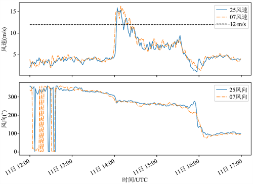
Figure 1. Time series diagram of wind direction and wind speed change of runways R07 and R25 at Urumqi Airport from 12:00 to 17:00 on June 11. (The blue solid line is the wind direction and speed of runway R25, the orange dashed line is the wind direction and speed of runway R25, and the black dashed line represents the wind speed of 12 m/s)
图1. 乌鲁木齐机场6月11日12时~17时R07及R25号跑道风向风速变化时间序列图。(蓝色实线为R25号跑道风向风速,橘色虚线为R25号跑道风向风速,黑色虚线代表风速为12 m/s)
3.2. 天气形势及条件分析
图2为2021年6月11日12时高空及地面形势图。500 hpa上,11日12时,北疆地区位于巴尔喀什湖以北高空槽前部,槽底不断分裂小股冷空气影响新疆地区,为北疆西部、天山山区及其两侧和本场雷暴天气提供了有利的触发机制(图2(a))。700 hpa上,高空槽位于巴尔喀什湖,新疆地区受槽前偏西、西南气流控制,中纬度暖湿气流不断进入北疆区域,为此次大风、短时强对流和降水提供了热力和水汽条件(图2(b))。700 hPa~500 hPa系统略前倾,坡度大,预示着系统后续将加速东移南下。从高空槽垂直分布位置看,坡度较陡,易引发夏季的强对流天气。850 hpa上,北疆沿天山一带受西北风带控制,有明显的风向风速辐合,配合天山北坡地形的强迫抬升作用,造成强上升运动,为此次强对流天气提供了有力的动力条件。同时850 hPa上北疆沿天山一带的强西北风,引导上游的对流云向东南方向移动,进而影响到了本场(图2(c))。地面图上,西伯利亚地区受东西向高压带控制,北疆地区位于高压底前部,有小高压分裂东移入侵新疆地区。北疆大部地区地面气温较高,大于30℃;冷空气东移入侵北疆,冷暖空气交汇,造成区域性的强对流天气(图2(d))。
3.3. 风切变特征分析
图3是乌鲁木齐机场跑道两端风速差、风向差和水平风切变。由图可见,14:00前,机场跑道两端风速小于3 m/s,风向差最大时达到75˚,跑道两端水平风切变值小于4 m/s,未超过警戒值。14:00开始跑道两端风速差骤增至5 m/s以上,风向较为一致,风向差小于30˚,跑道两端水平风切变超过7.7 m/s警戒标准,但持续时间较短,10分钟后风切变值明显下降。
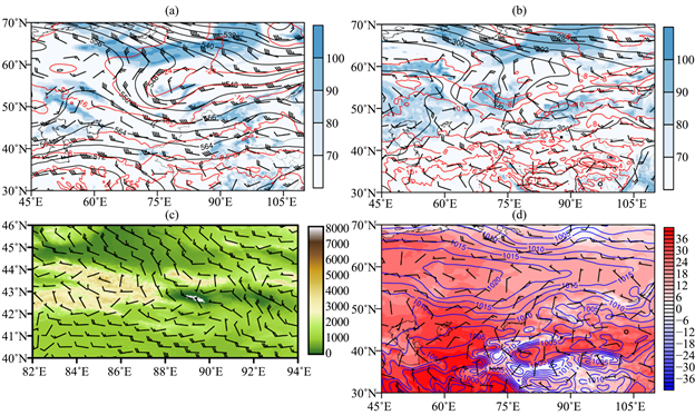
Figure 2. Wind field, potential height field (black solid line, unit: gpm), temperature field (red solid line, unit: ˚C), relative humidity (blue shadow, unit: %), (b) 700 hPa wind field, potential height field, temperature field, relative humidity, (c) 850 hPa wind field superimposed terrain, (d) surface pressure field (unit: hPa) situation diagram
图2. 2021年6月11日12时(a) 500 hPa风场、位势高度场(黑色实线,单位:gpm)、温度场(红色实线,单位:℃)、相对湿度(蓝色阴影,单位:%),(b) 700 hPa风场、位势高度场、温度场、相对湿度,(c) 850 hPa风场叠加地形,(d) 地面气压场(单位:hPa)形势图
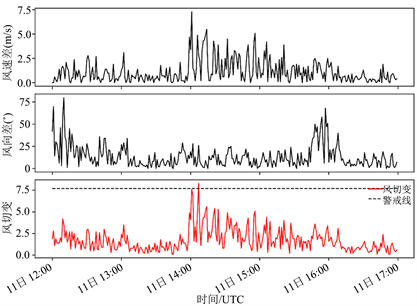
Figure 3. Time series of wind speed difference (m/s), wind direction difference (˚) and wind shear (m/s) at Runways 07 and 25 of Urumqi Airport from 12:00 to 17:00 on June 11, 2021
图3. 2021年6月11日12:00~17:00乌鲁木齐机场07及25号跑道风速差(m/s)、风向差(˚)及风切变(m/s)时间变化序列图
图4是2021年6月11日12:00~17:00乌鲁木齐机场跑道07-25方向风速差、风向差及风切变值的散点图。从图4(a)可以看出,当跑道两端风速差为0~6 m/s时,风切变较弱;当跑道两端风速差大于6 m/s时,无论风向差值大小,均可能出现风切变超标。从图4(b)可以看出,当跑道两端风向差在0˚~30˚之间时,风切变大小与风速差大小基本一致;两端风向差在30˚~90˚之间时,风速差异对风切变的影响权重逐步增大,并且风切变值均大于风速差值;两端风向差大于90˚时,不论风速差大小,均有可能出现风切变超标情况。

Figure 4. Scatter plot of wind speed difference, wind direction difference and wind shear value in direction 07-25 of runway of Urumqi Airport from 12:00 to 17:00 on June 11, 2021. (a) Wind speed; (b) Wind Direction
图4. 2021年6月11日12:00~17:00乌鲁木齐机场跑道07-25方向风速差、风向差及风切变值的散点图。(a) 风速;(b) 风向
6. 结论
(1) 此次雷雨大风天气为区域性强对流天气。500 hPa高空槽槽底不断分裂小股冷空气影响新疆地区,区域雷雨天气提供有利触发机制。700 hpa西南气流输送暖湿气流进入北疆区域,提供热力和水汽条件。850 hpa北疆沿天山一带受西北风带控制,明显的风向风速辐合配合天山北坡地形的强迫抬升作用,造成强上升运动,提供了动力条件。地面图上,北疆大部区域地面气温高,冷空气东移造成冷暖空气交汇,造成区域性的强对流天气。
(2) 雷雨天气初期冷空气进入本场,风速骤增时易产生跑道两端水平风切变超标准情况,虽然风切变超标情况持续时间较短,但仍会造成航空器起降过程中难以保持飞行姿态,严重影响航空器飞行安全。
(3) 跑道两端风速差大于6 m/s时,无论风向差值大小,均可能出现风切变超标。跑道两端风向差在30˚~90˚之间时,风速差异对风切变的影响权重逐步增大,并且风切变值均大于风速差值;两端风向差大于90˚时,不论风速差大小,均有可能出现风切变超标情况。
文章引用
丁 旭,杜安妮,李静轩,尹才虎. 乌鲁木齐机场2021年6月11日雷雨大风天气特征分析
Analysis of Thunderstorm and Gale Weather Characteristics at Urumqi Airport on June 11, 2021[J]. 自然科学, 2024, 12(01): 106-112. https://doi.org/10.12677/OJNS.2024.121013
参考文献
- 1. 张琳娜, 冉令坤, 李娜, 等. 雷暴大风过程中对流层中低层动量通量和动能通量输送特征研究[J]. 大气科学, 2018, 42(1): 178-191.
- 2. 陈晓欣, 俞小鼎, 王秀明. 中国大范围雷暴大风事件(Derechos)研究: 时空分布、环境背景和对流系统形态特征[J]. 气象学报, 2022, 80(1): 67-81.
- 3. 沈杭锋, 张红蕾, 高天赤, 等. 浙江盛夏一次强对流天气的特征及其成因分析[J]. 气象, 2016, 42(9): 1105-1113.
- 4. 陈阳权, 杜安妮, 丁旭, 等. WRF模式对乌鲁木齐机场终端区一次强对流天气过程的模拟分析[J]. 沙漠与绿洲气象, 2022, 16(2): 48-55.
- 5. 文雪. 2022年6月26日新津机场雷雨大风天气过程分析[J]. 民航学报, 2023, 7(2): 60-63.
- 6. 王维刚, 金龙. “0901”虹桥机场雷雨天气分析与气象服务[J]. 民航学报, 2019, 3(4): 38-43.
- 7. 张亚莉, 郭俊含, 李静轩, 张宇翔, 尹才虎. 乌鲁木齐机场2022年夏季1次短时雷雨大风天气分析[J]. 自然科学, 2023, 11(2): 261-268. https://doi.org/10.12677/OJNS.2023.112031
- 8. 张天成, 杜安妮, 郭俊含, 尹才虎. 2021年5月29~30日乌鲁木齐机场雷暴天气分析[J]. 自然科学, 2022, 10(1): 79-89. https://doi.org/10.12677/OJNS.2022.101010
- 9. 张宇翔, 杜安妮, 郭俊含, 朱国栋, 朱国栋. 乌鲁木齐机场一次间歇性雷雨天气过程诊断分析[J]. 自然科学, 2023, 11(5): 864-873. https://doi.org/10.12677/OJNS.2023.115103
- 10. 杜安妮, 陈阳权. 乌鲁木齐机场1次短时雷雨大风天气特征及成因分析[J]. 气象水文海洋仪器, 2021, 38(4): 59-62. https://doi.org/10.19441/j.cnki.issn1006-009x.2021.04.017